Your carbon credit creation,smarter,higher quality.
Japan's only carbon credit DX service "Ecoulu DMRV"
From planning to data capture and reporting—streamline the workflow with digital tools. Break free from paper-based work and deliver higher-quality outcomes with less time and cost.
Why teams choose Ecoulu DMRV
Practical tools for teams creating forest credits—focused on traceability and reducing admin overhead.
70%reduced
Work time
Move away from paper and manual workflows. Digitization improves both field and office work dramatically.
Higher-quality credits
Ensure transparency with Digital MRV. Link location, photos, and records with a clear history so buyers and verifiers can review evidence confidently.
Easy to get started
A reasonable pricing model lets you start small. Improve transparency and create additional value without sacrificing margin.
Traditional workflow vs Ecoulu DMRV
A workflow comparison for J-Credit creation (forest credit example).
Planning
Create a work map by marking work areas and monitoring plots on paper maps
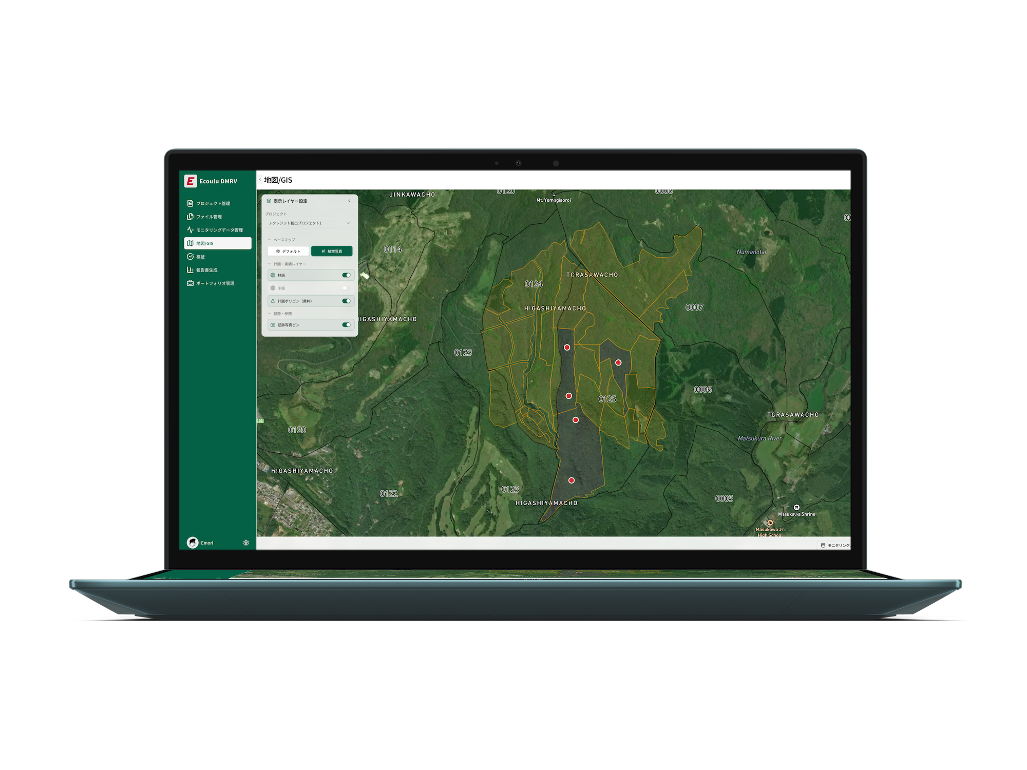
- Record work areas and monitoring plots in GIS
- Maps you create are automatically synced to the mobile app
Navigation
Reach work areas/monitoring plots using paper maps
(Hard to determine current location and pinpoint correct target locations)
- Use a mobile app with mapped targets so teams can reach locations even without local familiarity
- Works offline
Work & records
Perform operations/protection/monitoring and record results using a camera and field notebooks
(Monitoring rules can be complex and specialized. There is a risk of rework after third-party feedback.)
- Photos and notes captured in the app are automatically organized and linked in GIS
- Aerial survey data, LiDAR survey services, and satellite monitoring are also supported (contact us for details)
GIS entry
Return to the office and enter collected data into GIS
(Identifying photo locations and linking/organizing data is time-consuming)
- — No work required (auto-synced)
Reporting
Create monitoring reports by referencing project plans and operation/monitoring results
(Many required fields. Submissions must use the latest templates, which update frequently—creating a risk of rework.)
- Monitoring reports are automatically generated by AI
- Make credit creation possible without specialized expertise
Planning
Create a work map by marking work areas and monitoring plots on paper maps
- Record work areas and monitoring plots in GIS
- Maps you create are automatically synced to the mobile app
Navigation
Reach work areas/monitoring plots using paper maps
(Hard to determine current location and pinpoint correct target locations)
- Use a mobile app with mapped targets so teams can reach locations even without local familiarity
- Works offline
Work & records
Perform operations/protection/monitoring and record results using a camera and field notebooks
(Monitoring rules can be complex and specialized. There is a risk of rework after third-party feedback.)
- Photos and notes captured in the app are automatically organized and linked in GIS
- Aerial survey data, LiDAR survey services, and satellite monitoring are also supported (contact us for details)
GIS entry
Return to the office and enter collected data into GIS
(Identifying photo locations and linking/organizing data is time-consuming)
- — No work required (auto-synced)
Reporting
Create monitoring reports by referencing project plans and operation/monitoring results
(Many required fields. Submissions must use the latest templates, which update frequently—creating a risk of rework.)
- Monitoring reports are automatically generated by AI
- Make credit creation possible without specialized expertise
Supported methodologies
J-Credit methodologies supported today, with coverage expanding over time.
J-Credit Supported
Forest
FO-001, FO-003
Solar PV
EN-R-002
EV
EN-S-012
Biochar
AG-004
Paddy drainage
AG-005
Energy efficiency
General efficiency methodologies
Coming soon
Flexible plans Built for small starts
We propose the best plan based on your project scope and operating model. Please contact us for details.
Plans designed for gradual scale-up
From initial rollout to phased expansion, we propose a plan aligned with your project scale. Details are shared upon inquiry.
Affordable plans
Operate with a cost-efficient structure designed to keep fixed costs under control.
Easy to start small
Begin with a small rollout and expand as project volume grows.
Add options as needed
Validation features are optional, so you can extend only when required.